Map exploration
Phase 4 adds a stronger exploration flow with map clusters, nearby waterbody cards, and faster movement from map to rules.
ON钓爷 / ON Fishing · Phase 4 live on the App Store
ON钓爷 is a Chinese-friendly Ontario fishing app for anglers who want to quickly understand nearby waterbodies, FMZ guidance, species limits, official access points, weather reference, and key restrictions before heading out.
查水域,查鱼种,查入口,查环境。把出发前的复杂判断压成一张清楚地图。
Independent app. Not affiliated with or endorsed by the Government of Ontario. Always verify official regulations before fishing.
Why it exists
Ontario fishing information can involve FMZ zones, waterbody exceptions, open seasons, fish species limits, bait rules, gear notes, official access points, weather warnings, and legal wording that is not friendly on a phone screen.
ON钓爷 turns that pre-trip checking into a calmer mobile flow: start from the map or nearby waterbody, review species rules and environment reference, then keep the official verification habit intact.
Phase 4 release
Phase 4 makes ON钓爷 more useful before leaving home, at the car, and near the shoreline.
Phase 4 adds a stronger exploration flow with map clusters, nearby waterbody cards, and faster movement from map to rules.
Anglers can review nearby official access points such as boat launches, shore access, piers, parking hints, and map handoff.
Weather, wind, sunrise/sunset, humidity, alerts, and caution notes are surfaced as trip-planning context, not bite guarantees.
Species cards can show rule status together with habit/environment guidance, helping anglers understand what to check before casting.
Core features
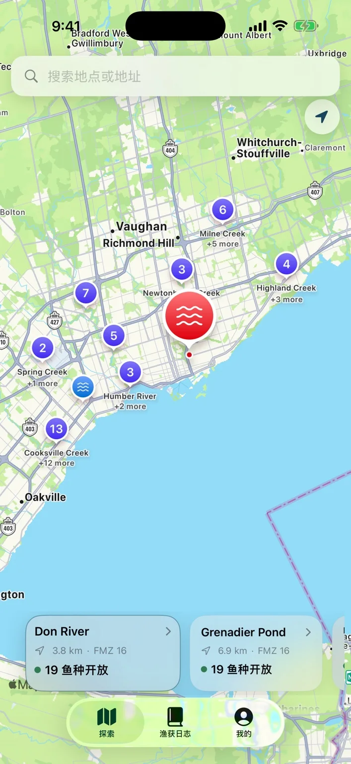
Start from nearby lakes, rivers, ponds, and Toronto-area fishing waters instead of opening a giant regulation document first.
Use map clusters and nearby cards to discover waterbodies around the GTA, Lake Ontario shoreline, and Ontario fishing regions.
See nearby official fishing access points, boat launches, shore access, distance, parking and accessibility notes when available.
Check species rules together with weather, wind, alerts, waterbody notes, and practical trip-planning context.
Ontario fishing app
If you are searching for an Ontario fishing regulations app, a Chinese Ontario fishing app, FMZ rule lookup, waterbody exceptions, or a faster way to check fishing access points before a trip, ON钓爷 is built for that exact pre-trip moment.
The app focuses on practical reading: nearby waters, map exploration, official access point context, species cards, season status, catch limits, size notes, weather and wind reference, and clear reminders to confirm official Ontario regulations.
Screenshots
These screenshots show the current ON钓爷 flow across map discovery, access points, environment reference, and species rule details.
Explore nearby Ontario waterbodies through map clusters, location-aware cards, and quick access to fishing rule context.
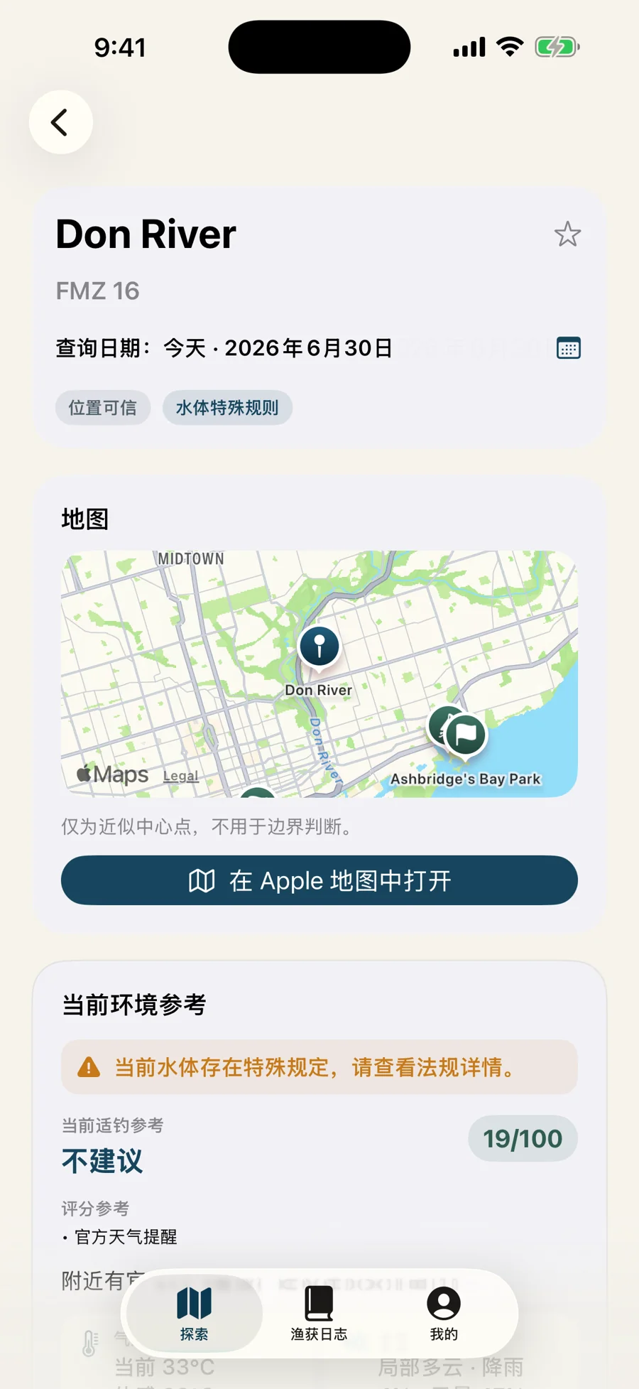
Open a specific waterbody to see FMZ, map preview, official access points, environment reference, and rule sections.
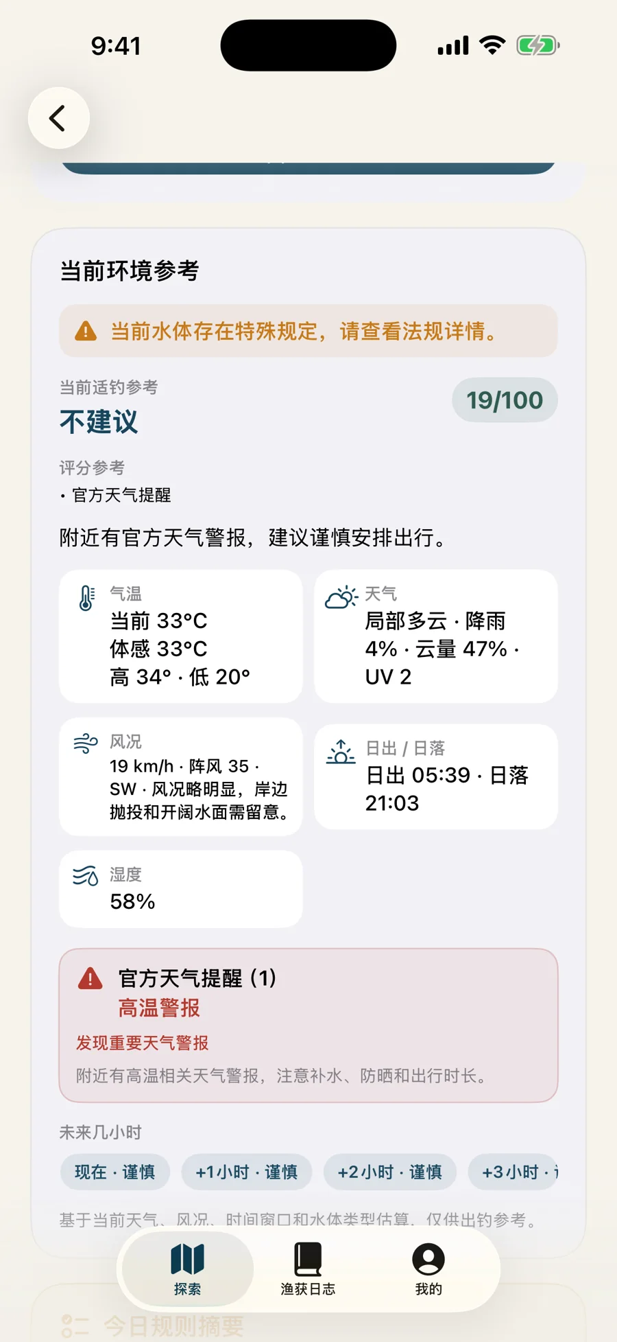
Review weather, wind, humidity, sun timing, warnings, and trip-planning signals as reference, not as a guarantee.
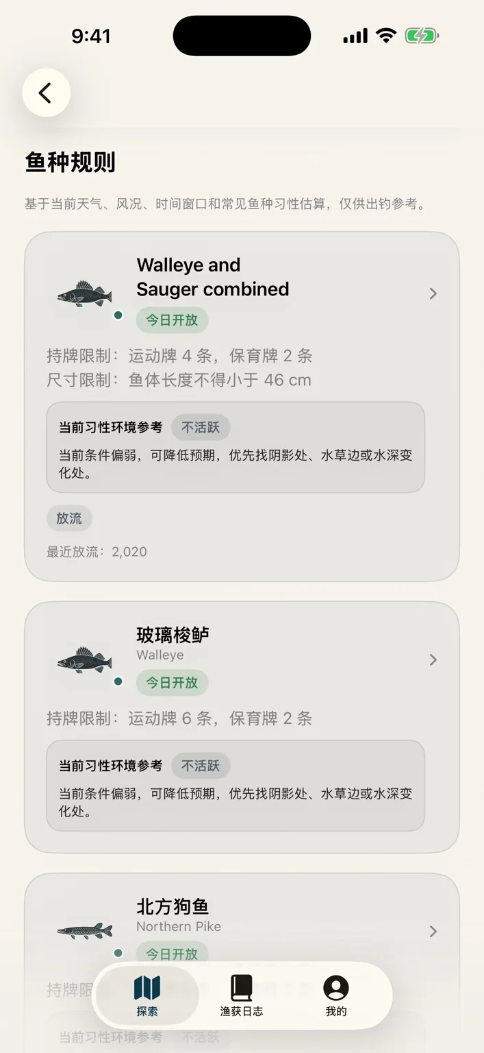
Check fish species cards with season status, limits, size notes, and current habit/environment hints.
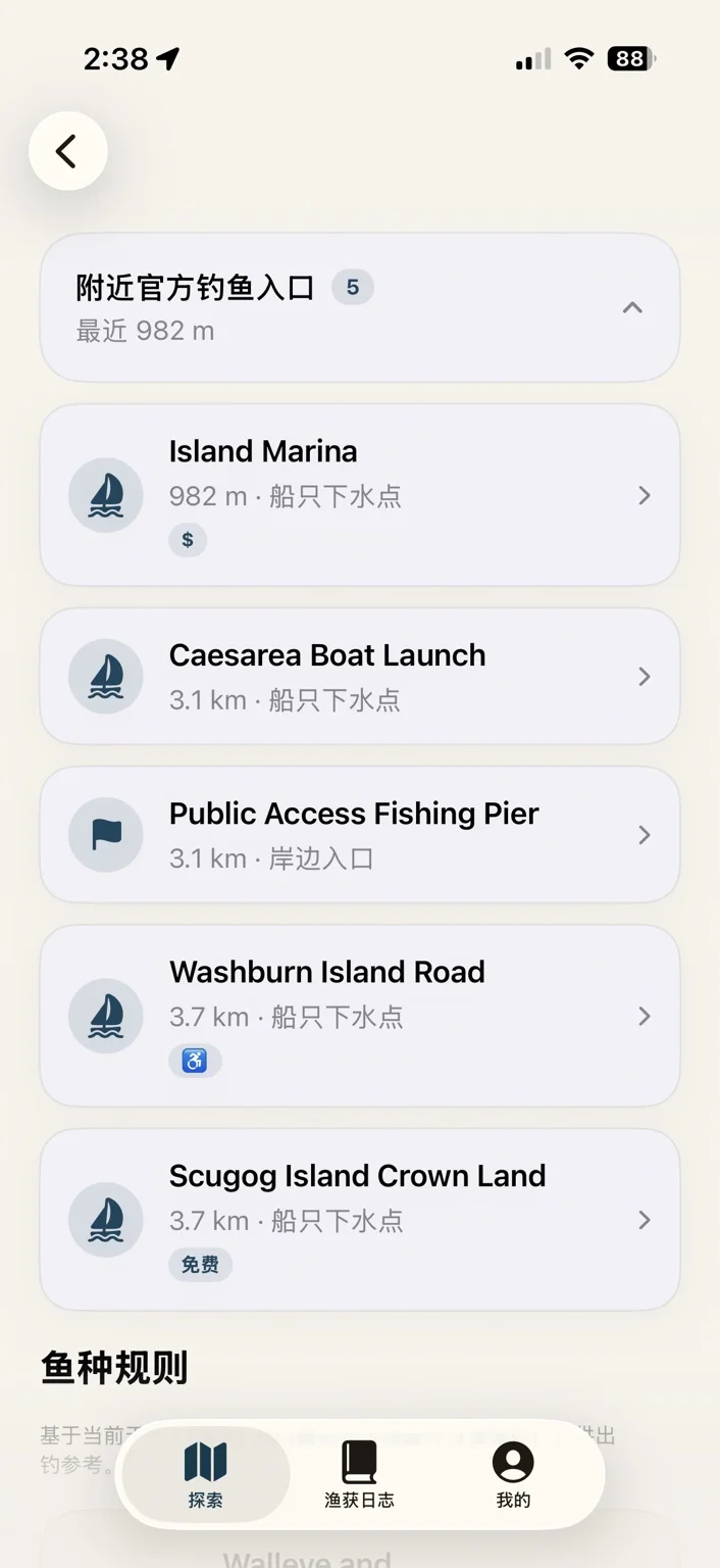
Find nearby official fishing access points, including boat launches, shore access, pier entries, and distance context.
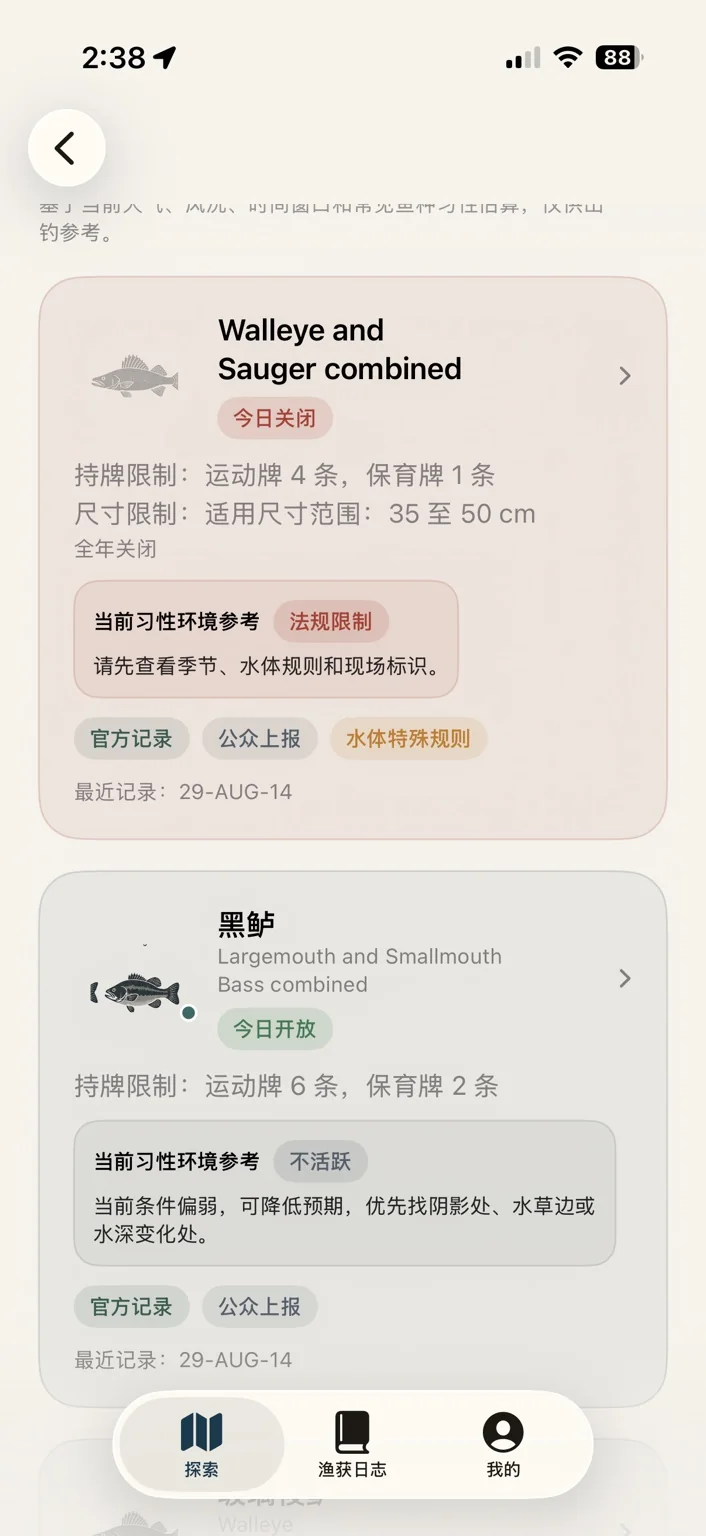
See rule status together with caution labels, official record markers, public reports, and special waterbody notes.
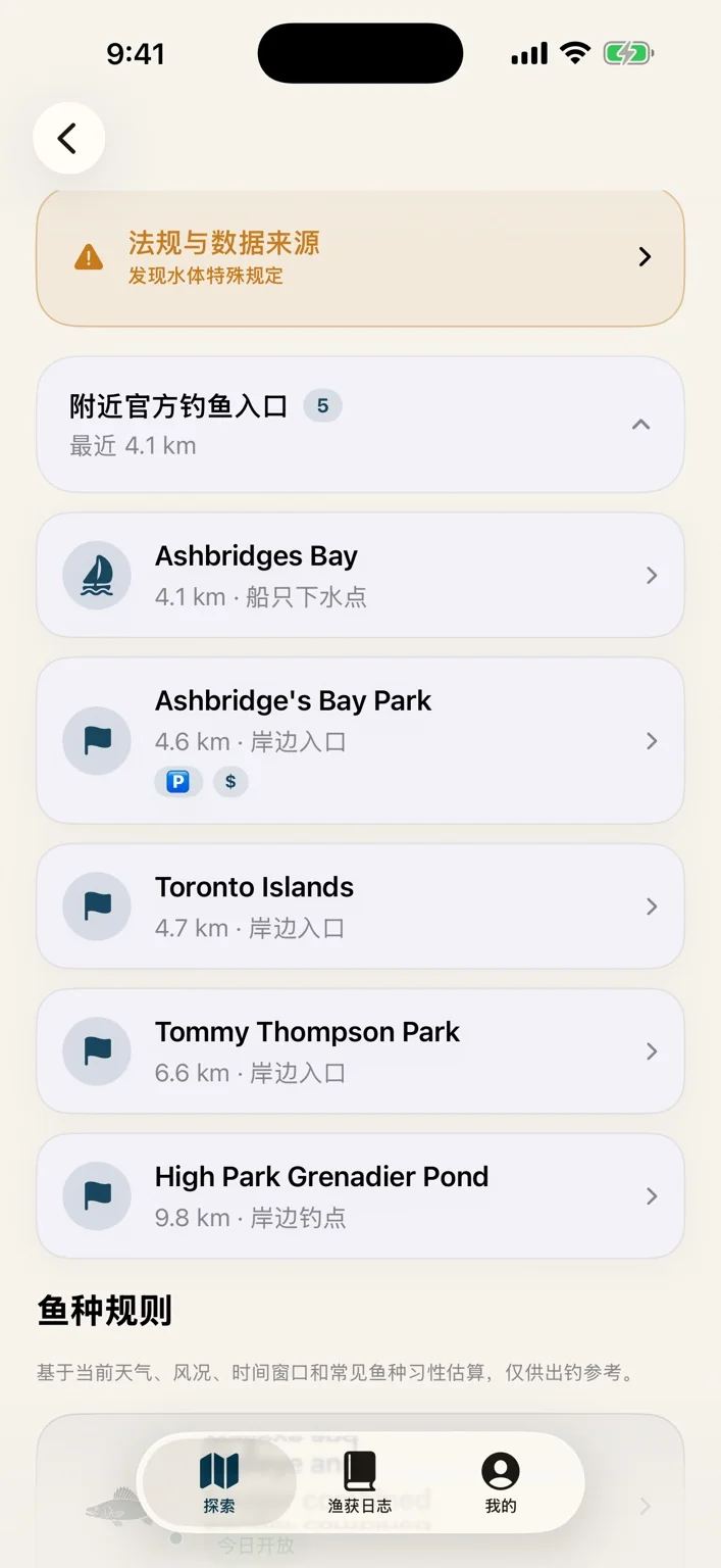
Review access points around Toronto-area waterbodies and quickly understand where the last-mile entry may be.

The ON Fishing brand now has a stronger outdoor identity for sharing, landing pages, and social promotion.
How to use
Search a waterbody, city, FMZ, or fish species, or start from the nearby map when planning a trip around Ontario.
Review FMZ, location confidence, map context, official access points, and quick species availability before you decide where to go.
Tap into species rules, season dates, catch limits, size notes, warnings, environmental reference, and habit guidance.
Use ON钓爷 as a fast reading assistant, then confirm with official Ontario fishing regulations when legal certainty matters.
What comes next
Trip sessions with multiple catches, photos, notes, and saved waterbody context.
Weather, wind, water level, surface temperature, and other signals explained as context, not as fish-bite fortune telling.
Future user reports, local notes, and lightweight community planning without turning the app into noise.
Q&A
ON钓爷 / ON Fishing is a Chinese-friendly Ontario fishing app for waterbody lookup, FMZ guidance, fish species rules, official access points, and trip-planning reference information.
No. ON钓爷 / ON Fishing is an independent fishing helper built by Let’s Moyu. It is not affiliated with, endorsed by, or operated by the Government of Ontario or any official regulatory agency.
No. The app is a convenient reading and lookup assistant. Fishing rules can change, local exceptions may be complex, and users remain responsible for checking official Ontario fishing regulations.
Phase 4 expands ON钓爷 beyond basic rule lookup with stronger map exploration, nearby waterbody cards, official fishing access points, environment reference, weather alerts, and species habit context.
No. The environmental information is positioned as trip-planning reference. It is not a guaranteed fish-bite prediction and should not replace judgment, local knowledge, or official rules.
It is especially useful for Ontario anglers who prefer Chinese explanations while still seeing English fish names, waterbody names, FMZ context, and terms needed for official cross-checking.
Nearby lookup may use location permission if you choose to enable it. Basic rule lookup can also begin through search and manual selection.
Ontario fishing regulations app, Chinese Ontario fishing app, FMZ rules, waterbody exceptions, fishing access points, species limits, fishing map, and Ontario fishing trip planning.
ON钓爷 / ON Fishing
Built for Ontario anglers who want less searching, clearer context, and a more confident start to the trip.